Circuit Trails
The Circuit Trails are a diverse and growing network of trails for our the Greater Philadelphia/Southern New Jersey region to connect, gather, commute, recreate and discover new destinations. With more than 500 miles of completed, funded or planned trails, our network is still growing toward its ultimate goal of 850+ miles across the nine-county region.
Some of the region’s most iconic trails — the Schuylkill River Trail and Schuylkill Banks Boardwalk, the Manayunk Bridge, Cooper River Trail, Pennypack Trail, Chester Valley Trail — are part of the Circuit Trails network.
With hundreds of miles of trails #OnTheCircuit, there are endless opportunities for you to choose to walk, run, ride, roll, play, commute or simply enjoy time in nature.
Philadelphia
- Cynwyd Trail
- Wissahickon Valley Trail
Montgomery County
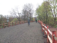
The 19-mile Perkiomen Trail runs through the Perkiomen Creek Valley from its junction with the Schuylkill River Trail at Oaks, Upper Providence Township to the largest County Park, Green Lane Park. Most of the trail is a 10-foot wide cinder or stone aggregate (non-paved) surface with grass shoulders. Selected sections are paved where deemed appropriate.
The multi-use trail follows the Perkiomen Creek and connects three County parks (Lower Perkiomen Valley Park, Central Perkiomen Valley Park, and Green Lane Park) and two County historic sites ("Mill Grove" – Audubon Wildlife Sanctuary and Pennypacker Mills). It passes directly through ten (10) municipalities making connections to numerous municipal parks and open spaces along the scenic waterway. The trail provides access to Valley Forge National Historical Park via its connection to the Schuylkill River Trail extension.
phone: (610) 287-6970
- Audubon Loop Trail
- Cross County Trail – Details
- Chester Valley Trail
- Valley Forge NHP trails
Berks County
Schuylkill County
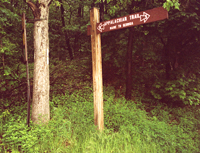
Port Clinton is a small town with a big story. The town of 300 sits in the gap where the Schuylkill River cuts through the in the Appalachian Mountains, and was a transportation hub throughout the 18th, 19th, and 20th centuries. The Schuylkill River, Schuylkill Navigation System, Pennsylvania Railroad, and the Reading Railroad all intersected in Port Clinton, making it one of the most important points of commerce for decades.
Access to the Appalachian Trail is located in the western end of the Borough along the railyards of the Blue Mountain, Reading, and Northern Railroad.
USE EXTREME CAUTION when entering and leaving the trail, as it is necessary to pass through an active railyard to gain access.